Activity | Hiking |
Destination | Carrington Bay, Cortes Island |
Date | 15 April 2015, Wednesday |
Trip Coordinator | Margot Wood |
Contact Info | 250.285.2393. You MUST contact Margot by Monday, April 13th, 10 a.m. in order to arrange transportation. |
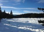
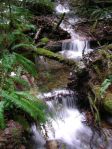
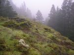
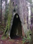
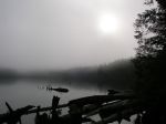
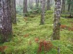
Description | This hike will be hosted by the Children’s Forest Board of Directors. We will be met at the Cortes Ferry Parking and driven to the start of the hike. Our guide is a long time resident of Cortes Island, knows the area well and he is filled with the history and knowledge of this beautiful park. Carrington Bay Regional Park is one of the most widely used mature forest destinations on the island. The main trail out to the lagoon is an old dirt road bed and the many other trails through the forest are suitable for both hiking and mountain biking. The lagoon entrance is a narrow channel through which the tide flows, mixing salt and fresh water for abundant aquatic life. The forests are also home to a significant amount of wildlife, including several species at risk. The mature forest on the way out to the lagoon also hosts a whole network of hiking and biking trails, with several “you are here” maps along the way that will also help you to locate two historic homesteads. Much of the forest that you will hike through to get to the lagoon is private managed forestland. The Forest Trust for the Children of Cortes Island Society has been formed to purchase these forestlands and hold them in trust for the children of Cortes Island in perpetuity. For more information visit http://www.corteschildrensforesttrust.org. Park at the trail head on Coulter Bay Rd. Access is off Carrington Bay Road in Whaletown or down Jimmy Smith Road, through the Cortes Pit. Estimated walking time for several trails: allow at least 2-3 hrs. |
Meeting Place | Cortes ferry line-up |
Departure Time | 9:05 a.m. ferry. We plan to return on the 1:50 p.m ferry or the 3:50 p.m. at the latest. |
Difficulty | Easy & beautiful |
Costs | Ferry fare |
Trip limits | none |
Dogs? | Yes. Be aware wolves in the area. |
Notes: | Bring lunch. This trip is weather dependent. |
Monthly Archives: January 2015
Karst Formations – 21 March 2015
Activity | Naturalist outing |
Destination | Quadra’s Karst formations |
Date | 21 March 2015, Saturday |
Trip Coordinator | Richard Leicester |
Contact Info | 285-2663; please contact the coordinator by Thursday if you are interested in going |
Description | Visit some of Quadra’s Quatsino limestone formations, an area which contains karst sinkholes, intakes, resurgences and underground streams. We will visit two or three areas, which involves a bit of driving on logging roads and bush walking. We will not be walking in caves. |
Meeting Place | Heriot Bay store parking lot for car pooling. High clearance vehicles will be preferable. |
Departure Time | TBA |
Difficulty |
Easy to moderate |
Costs | none |
Trip limits | none |
Dogs? | no |
Notes: | Bring lunch and gear appropriate for the weather. Also, bring a flashlight to see into these geological formations. |
Blindman’s Bluff & Eagle Ridge – 4 March 2015
Activity | Hiking |
Destination | Blindman’s Bluff & Eagle Ridge |
Date | 4 March 2015, Wednesday |
Trip Coordinator | Les Hand |
Contact Info | 285-2029; please contact the coordinator at least two days in advance. |
Description | These are two short hikes linked by proximity. The route takes us through open forest over mossy bluffs leading to great views. About 2½ hours. |
Meeting Place | Heriot Bay Tru Value parking lot |
Departure Time | 10:00 |
Difficulty | moderate |
Costs | none |
Trip limits | none |
Dogs? | |
Notes: | Bring lunch. Hiking poles may be useful but not essential. |
Stramberg Old Growth – 1 April 2015
Activity | Hiking |
Destination | Stramberg Old Growth grove |
Date | 1 April 2015, Wednesday |
Trip Coordinator | Norris Weimer |
Contact Info | 285-3710 or norris.weimer@ualberta.ca |
Description | This trail begins near Village Bay Lake and follows open meadows leading into and through the forest. The reward at the end of the hike is a grove of old growth firs. This is not an official trail and route-finding can be an issue. Although there was work on this trail last summer, there has also been quite a lot of blow-down this winter, so progress may be slow. About 13 km; 5 hours or more. |
Meeting Place | Heriot Bay Tru Value parking lot |
Departure Time | 9:00 |
Difficulty | moderate |
Costs | none |
Trip limits | none |
Dogs? | no |
Notes: | Bring lunch. This walk is very wet in places. |
Hiking Maud Island 11 Mar 2015
POSTPONED
Activity | Hiking |
Destination | Maud Island |
Date | 11 March 2015, Wednesday |
Trip Coordinator | Debbie Quigg |
Contact Info | 285-3710 or debbie.quigg@ualberta.ca; please contact the coordinator in advance of the trip |
Description | Hike to Maud Island through varied forest over level and undulating trails. We hope to have views from Mt. Lolo and from the Narrows. We will also see the state of construction of the tidal turbines at the Canoe Pass causeway. About four hours. |
Meeting Place | Heriot Bay Store for car pooling |
Departure Time | 10:00 |
Difficulty |
Easy to moderate |
Costs | none |
Trip limits | none |
Dogs? | |
Notes: | Bring lunch. |
Hiking on Demand – February 2015
Activity | Hiking |
Destination | Hiking on demand |
Date | February |
Trip Coordinator | Julie Mellanby |
Contact Info | 285-3978 |
Description | The last three weeks of February are open to your suggestions for hiking destinations. If you want to go hiking, give Julie a call and suggest a time and a place. |
Meeting Place | TBA |
Departure Time | TBA |
Difficulty | TBA |
Costs | |
Trip limits | |
Dogs? | |
Notes: |
Mine Lake Bluff – 27 January 2015
Activity | Hiking |
Destination | Mine Lake Bluff |
Date | 27 January 2015, Tuesday |
Trip Coordinator | Debbie Quigg |
Contact Info | phone 3710 or debbie.quigg@ualberta.ca. Please contact the coordinator in advance. |
Description | We will leave from the parking area on the road near the Mine Lake access and walk to Camp Homewood. From there the route ascends the bluff to the north of Mine Lake with great views (weather permitting). A loop will be made by a trail which descends to the north and circles back to the trail just before Camp Homewood. The route up the bluff can feel a bit exposed. This is a hike, not a climb. |
Meeting Place | Heriot Bay Tru Value parking lot |
Departure Time | 10:00 |
Difficulty | moderate |
Costs | none |
Trip limits | none |
Dogs? | |
Notes: | Bring lunch and gum boots. We will need the rubber boots for the section between the road and Camp Homewood. From there, we can wear hiking shoes/boots. |
B&B Trail – 21 January 2015
Activity | Hiking |
Destination | B&B Trail |
Date | 21 January 2015, Wednesday |
Trip Coordinator | NA |
Contact Info | please respond to qioutdoorclub@gmail.com |
Description | We will follow the recently improved but unofficial B&B Trail, making a loop with a flagged route back to the Thompson Road. If the group wants, we will also explore a route along the ridge. Between 1½ and 2½ hours. |
Meeting Place | Thompson Road trailhead |
Departure Time | 10:00 |
Difficulty | moderate |
Costs | none |
Trip limits | none |
Dogs? | |
Notes: | Bring water, a snack and a hiking pole. |
Trip Report – Mt. Washington 14 Jan 2015
Five of us went to Raven Lodge at Mt. Washington and hiked their snowshoe trails. We were way above the fog, so it was sunny and warm (9°C). It was spring skiing conditions, with only about a foot of packed snow, which was enough for snowshoeing. Only four snowshoe trails were open, but we did all of them, about 8.5 km, about four hours.
- Mt. Albert Edward
- Mt. Washington
- Paradise Meadows
(click on photos to view larger)
Trip Report – Morte Lake Loop 7 Jan 2015
This trip was scheduled on short notice, after the postponement of the hike to the Stramberg old growth grove due to snowfall. There was virtually no snow on the Morte Lake trail, most of the snow was in the parking lot. The four of us took a leisurely pace on the gradual walk up the old logging road leading past lovely forest, glowing moss, creeks and ponds. It was very quiet and foggy. We stopped for lunch at the picnic area on the south shore and took the side trip to the viewpoint on the southeast. Near the end, we crossed the creek and returned to the parking lot on the mountain bike trail. About 4 hours; 10.8 km.
- old cedar “telephone booth”
(click on photos to view larger)