Hiking – Shellaligan Loop – 15 Feb 2023

Activity Hiking
Destination Shellaligan Loop
Date 15 Feb, Wednesday
Trip Coordinator Brent Henry
Contact Info brenthenrys@gmail.com or text: 250-205-1106. Please contact the coordinator by Monday night.
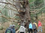
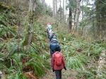
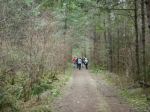
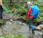
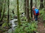
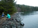
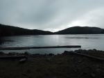
Description This will be the shorter loop, most often started near the second parking lot, with a short walk down the road to access the coastal trail. This follows the shoreline and rocky outcrops to the point near the entrance to Village Bay. It then continues to the oyster farm, from where we would head inland, up the drainage and further on to the parking lot. As this is done so often in this direction, we may do this trail in the opposite clockwise direction, just for a change, heading inland from the parking lot.
Meeting Place Heriot Bay store parking lot
Departure Time 10:00
Difficulty
Moderate, with pronounced step-ups over the rocks on the coastal section. Somewhat steep on parts of the interior section between the fish farm and the parking lot. Not a bad idea to bring hiking poles.
Costs None
Trip limits 10
Dogs? Yes, if under control. Owners must bring a leash along.
Notes: This will be in winter, but will proceed unless we have severe weather, such as strong coastal winds. Please bring good rain wear, proper footwear for rough walking and spare clothing. this will be a 2-3 hour walk, and will have a stop for lunch, most likely midway at the point.
Advertisement

Trip Report – Kay du Bois Loop – 30 Jan 2023

Ten intrepid January hikers set out from the WaWaKai end of the Kay Dubois trail. The sky was milky and made a white canopy, the air nippy, and there was a pretty frosting on the fir branches and icicles in the ditches.  Our group followed the trail that turned right at the big tree and looped up the hill, following the logging trails to meet eventually with Cedar Road. We returned via Smiths Road back to warm up at the cabin of 665 WaWaKai Road. Many thanks to all who joined in!  (6.3 km; 2 hours walking)

Amanda

Many thanks to Amanda for her warm hospitality and snacks.
 
Click on photos to enlarge
 

Note: Hair ice forms on moist, rotting wood from broadleaf trees when temperatures are slightly under 0 °C (32 °F) and the air is humid.  In the year 2015, German and Swiss scientists identified the fungus Exidiopsis effusa as key to the formation of hair ice.  [Wikipedia]

Hiking – Kay du Bois Loop – 30 Jan 2023

Hiking – Carrington Bay and Forest – 6 March 2023

This hike is postponed due to snow conditions.

Activity Hiking
Destination Carrington Bay and Forest, Cortes Island
Date 6 March 2023, Monday
Trip Coordinator Debbie Quigg
Contact Info dmquigg@gmail.com or 3710.  Please contact the coordinator well in advance of the trip, so that car pools can be arranged.
Description After the ferry crossing we will drive to the Carrington trailhead and follow the trails to Carrington Bay and lagoon.  We will have lunch at Carrington Bay and continue on to Grandmother’s Grove following the stream.  We plan to return on the 3:50 pm ferry.
Meeting Place Cortes ferry line-up.
Departure Time 9:05 am ferry; vehicles need to be in the ferry line-up not later than 8:15 am for this  busy sailing.
Difficulty
Easy to moderate.
Costs Ferry travel costs; bring your experience card and ID
Trip limits 12
Dogs? no
Notes: Bring lunch and gear for weather.  Please arrange carpools in advance.

Hiking – Little Black Dress & Silk Stocking Loop – 20 Feb 2023


Activity Hiking
Destination Little Black Dress and Silk Stocking Loop
Date 20 February 2023, Family Day Monday
Trip Coordinator Debbie Quigg
Contact Info dmquigg@gmail.com or 3710
Description We will start at the Copperhead logging road and hike this counter-clockwise.  This includes a variety of terrain with open bluffs, a good forest (and recent logging), old mining and a forest lake.  Very roughly 7 km and 3 hours with lunch
Meeting Place Heriot Bay store parking lot
Departure Time 10:00
Difficulty moderate, with some steep sections
Costs none
Trip limits 12
Dogs? on leash
Notes Dress for the weather.  Bring lunch and poles if you use them.

Trip Report – South Morte Lake Loop – 25 Jan 2023

Once again we had big participation with 13 hikers.  The weather was not as nice as forecast, but adequate for the event.  It was soft and gentle even if grey.  We crossed the Walcan Rd and started out on Jackrabbit, crossing McKercher Creek and wandering up along the creek through the lush, green forest to Reed Lake.  There were a few wet crossings of minor creeks, but nothing unexpected in winter.  After re-crossing the Walcan Road, we followed along Reed and Mud Lakes until we took the Tripod trail over to the southwest corner of Morte Lake.  With the high water levels, the sandy beach was not inviting for lunch so we continued out to the point where we could perch with views of the lake.

After lunch, we followed the trail along the south shore at a brisk pace rejoining the main trail from the parking lot to Morte Lake at the east end of the lake.  We diverged at the Lower Deadfish junction and followed the creek down through this lovely, open forest back to the parking lot. It was a beautiful day for a forest walk.   (8.5 km; 3 hours)

Debbie

Click on photos to enlarge
 

Hiking -Morte Lake Loop – 25 Jan 2023

Trip Report – Plumper Bay – 18 Jan 2023

Since Mt. Washington did not have good conditions for snowshoeing, we substituted a hike to Plumper Bay and ten of us went.  The first half of this hike is along the Morte Lake to Maud Island trail.  This section is always nice.  Everything is covered with deep green moss and the trail is maintained.  The second part of the hike is along the old logging road between Plumber Bay and Mt. Lolo.  This road is still in amazing condition, but it suffers from trees falling across it.  A lot of deadfall.   Mostly not big trees, but it can make an obstacle course.  The route toward Plumber Bay gets cleared occasionally, but it is not “trail” maintained, and it will probably become an active logging road soon.  Right now it is quite clear except for one alder landslide.  The bay at the destination is a very nice picnic site.  Probably soon to be a log dump.  Until then it is well worth a visit.  

We could have had better weather.  The hints of blue sky we started out with turned into rain.  Quite cold rain, but no wind despite the windstorm the previous night.  Nonetheless, we had a good hike and were glad to go.  (6.3 km; 2hours 20 minutes)

Norris

Click on photos to enlarge
 

Hiking – Plumber Bay – 18 Jan 2023

Hiking – Plumper Bay – 18 Jan 2023

Activity Hiking
Destination Plumper Bay
Date 18 Jan, Wednesday
Trip Coordinator Norris Weimer
Contact Info norris.weimer@ualberta.ca or 3710.  Please contact the coordinator in advance.
Description A relatively flat and easy hike on old logging roads. The first part is the same as for going to Maud Island, then instead of turning left, we turn right. The trail is quite gradual down to the water.  Expect winter conditions with branches down and water on the trail.  Also recent logging in the area.  6 km roundtrip, about 2.5 hours including lunch. The destination is a nice grassy meadow on the waterfront of Plumper Bay (the first large bay north of Seymour Narrows). Bring lunch.
Meeting Place Heriot Bay Tru Value parking lot; we will convoy in our cars from there.
Departure Time 10:00
Difficulty Easy, but part of the route is unmaintained
Costs none
Trip limits 12
Dogs?
Notes: Bring lunch.

Trip Report – Overload Hike south of Walcan Rd – 9 Jan 2023

The good news was that Les’s scheduled Eagle Ridge hike was quickly filled, so two of the six Club members on the (unprecedented?) wait list decided to hike together, opting for the lovely forest trails south of Walcan Road. We set off on Jack Rabbit to Yellow Mud down to NightHawk Lake.  The recent heavy rains ensured that the trail was suitably “muddy” and, in places, virtually a small creek. We were delighted to see a small flock of six Trumpeter Swans gliding peacefully on Nighthawk Lake. After turning around at the logging road, we took Dicks Ride up the ridge, keeping right onto Cash Only, then right onto Plaything to wind our way back downhill to join up with Yellow Mud. At the junction leading to Plaything we were shocked to see clear cuts and new, wide gravel roads where there had been forest just a year ago. GPS, a map app, and mountain biking knowledge helped us reconnect with the forest trail “Plaything”. We returned to our cars just as the rain began again. Altogether a beautiful hike, and wonderful to know that 10 more members of our Club were also out enjoying our amazing trails.   2.5 hours

Valerie van Veen

Thanks to Valerie  for the photos.

Click on photos to enlarge


Trip Report – Eagle Ridge and Blindman’s Bluff – 9 Jan 2023

It was a cloudy cool day as 10 of us set out for a hike. We parked on the Copperhead logging road near the repaired culvert as there is more parking there. We first went up the Blindman’s Bluff trail. There were a few trees down and wet salal on the trail. All in all though it is in good condition and a fine hike. The many open bluffs give excellent views to the east and south. Visibility was good, but you could see the rain coming from the southeast. We paused for a brief snack, and to enjoy the views at the largest open area. We then circled back to the main trail.

The old road had quite a bit of water, running down it to the beaver pond. The water level was quite high in the pond and it was starting to rain now so we pushed on to Eagle Ridge. We stopped at the top to have a quick lunch. The rain started coming heavy so we headed back to the vehicles. We were all soaked by the time we got back to the vehicles but we’re quite happy that the first two hours were dry. 7 km, 3 1/2 hours.

Les

Thanks to Les and Norris for the photos.

Click on photos to enlarge

Hiking – Eagle Ridge and blindman’s Bluff – 9 Jan 2023

Kayaking – Maud Island and petroglyph at mouth of Morte Creek – 22 Mar 2023

This trip has been postponed to April 19th.

Activity Kayaking
Destination Maud Island and petroglyph at mouth of Morte Creek
Date 22 March 2023, Wednesday
Trip Coordinator Vic Gladish
Contact Info 250-285-2111; or 250-287-0459 text
Description According to Joy Inglis’s “Petroglyphs of Quadra Island” there are several petroglyphs located along Quadra’s west shore at the outflow of Morte Lake creek just east of Maud Island.
We will put in at the Leishmans Rd shore access by 1000 am and paddle north towards Maud Island. It is about a 1 hr paddle to the old village site of Kawstin at the outflow of Morte Lake creek. Depending on the amount of time spent here we may or may not paddle another 30 minutes into Maud Island and perhaps hike to the Seymour Narrows view point.
Meeting Place Shore access at Leishmans Rd
Departure Time 1000 on the water; meet at 0930
Difficulty
Moderate depending on weather and currents.
Costs None
Trip limits 8
Dogs? No
Notes: The tides/currents will be a factor. In order to view the petroglyphs I am planning our arrival for low tide with less attention to what the current will be doing. Poor weather and/or wind will mean this trip will be cancelled.
All participants must be equipped for ocean paddling in cooler weather – required equipment as per club guidelines (https://qioutdoorclub.files.wordpress.com/2018/07/paddling-guidelines-aug2018.pdf) and appropriate clothing.
I will email to each participant the petroglyph information relevant to the location.
Bring lunch, hot drinks, extra warm layers and something to sit on.