Trip Report – Thompson/B&B Trail loop – 20 Dec 2017

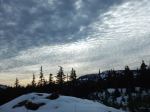
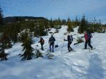
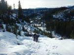
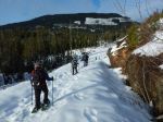
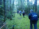
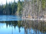
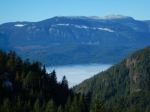
Five women met at the Thompson trailhead for a two and a half hour hike.  Having missed the threat of snow the previous day, we had a dry and sunny morning, with the temperature a bit above freezing and light wind from the north.  We headed up Thompson Trail to the first viewpoint.  After stopping to take in the views north and east to gloriously snowy mainland mountains, we walked north down the open ridge, dropping to the forest floor at the big maple tree.  From here, we followed a deer trail north to the B&B trail, turning south on the B&B at this point through pleasant second-growth forest and along a deeply-cut unnamed stream.  Reaching the Thompson Trail junction, we followed it south to the second viewpoint.  Climbing to the top of the ridge, we stopped for a break in the warm sun, again taking in snowy views to the east.  From here, we followed a rough off-trail route east and north down the ridge, eventually connecting to Thompson Trail and back to the vehicles.  The weather and company were perfect for a stunning December hike.

– Janis

hiking-thompson-bb-trail-loop-20-dec-2017

Advertisement

Trip Report – Mt. Washington Area – 13 Dec 2017

Eight of us put on our snowshoes — we also had one dog who was happy without snowshoes — and walked around one of the loops of logging roads from the Ramparts chain-up area near Mt. Washington.  There was no fog and the visibility was good.  We could even make out Mt. Baker 272 km away with our naked eyes.  The area has many good viewpoints of the snow covered mountains on the mainland.  The conditions were spring like.  The snow was crunchy — noisy on snowshoes — and it was very warm.  We ate lunch with the Whiskey Jacks.  6.0 km, 3.5 hours.

– Norris

(click on photos to view larger)

Snow – Mt. Washington Area – 13 Dec 2017

Hiking – Thompson-B&B Trail Loop – 20 Dec 2017


Activity Hiking
Destination Thompson-B&B Trail Loop
Date 20 December 2017, Wednesday
Trip Coordinator Janis McLean
Contact Info phone 3614
Description We will hike a loop on and off the trail from Thompson trail to B&B trail, and back to Thompson trail, with viewpoints at Thompson trail’s first and second viewpoints.
Meeting Place Thompson Road at the Thompson trailhead
Departure Time 10:00
Difficulty Easy to moderate (on viewpoint bluffs)
Costs none
Trip limits none
Dogs? okay if under control
Notes: Hiking pole(s) will be useful on the rock bluffs.  If the weather is decent, we will stop at the second viewpoint for tea and a snack.  Overall time should be 2 hours or so.

Trip Report – Deepwater Main and beyond loop – 6 Dec 2017

Six of us set out early in the thick fog (horizontally), but quickly broke through it to a stunningly bright, clear, sunny day, since the fog was thin (vertically).  We started hiking from the summit of the Deepwater Main road, up old logging roads, sometime steep and stoney due to water eroding them, other times soft, mossy carpeted through the forest.  At the top of the shoulder to the north of Mt. Seymour, there was still some snow on the ground from last week’s storms, and the lake was partly frozen. We stopped for lunch and the magnificent views of the snow-covered mountains to the north and fog-covered water passages.  Thanks to Les for the great buffet lunch including smoked salmon, veggies, cold cuts, cheese and cookies. Then we continued on, down the logging road to the Granite Bay Road to complete the loop.  7.1 km; 3¼ hours.

– Norris

(click on photos to view larger)

Hiking – Deepwater Main & beyond loop – 6 Dec 2017

Hiking – Shellaligan Forest Trails – 3 Jan 2018

Activity Hiking
Destination Shellaligan Forest Trails
Date 3 Jan 2018, Wednesday
Trip Coordinator Valerie van Veen
Contact Info vvv@qisland.ca or 285 2329
Description A post-Christmas social: walk through the forest (we will not do the Oceanside section of the trail) on good trails then all hikers are invited back to Valerie’s house for coffee/tea; bring any Christmas baking leftovers to share if you wish.
Meeting Place Meet at Heriot Bay store parking lot to carpool: meet up with coordinator at intersection of Valdes and logging road to trailhead at 10:15
Departure Time 9:55 am
Difficulty
Easy
Costs none
Trip limits none
Dogs? Must be under control at all times; must be left in cars at Valerie’s place
Notes: Hikers must contact coordinator by day before.


Trip Report – Deadfish-South Morte Lake Loop – 29 Nov 2017

On a blustery day under threat of rain, seven hikers enjoyed a brisk three hour hike around this loop connecting several mountain bike trails.   Beginning at the Morte Lake parking lot, we followed Lower Deadfish, Lost Rider, Ridge and Connector trails to the southwest corner of Morte Lake. The group encountered a few sprinkles here, which eventually passed. We followed the Morte Lake south trail, turned right on Nirvana and then left on 7 Sins with its seven switchbacks. At the junction of this trail and Upper Deadfish, we stopped for a brief lunch and took in the views across to Beech’s Mountain, Morte Lake and Discovery Passage. From there, it was downhill on Upper and Lower Deadfish along Little Morte Creek to the parking lot. Fortunately, we didn’t get rained on. Having had dry weather the previous day, there were very few puddles to cross. We agreed that it was a good workout and the lovely greens of the forest were at their peak. 8.7 km

Janis

Click on photos to enlarge

Hiking – Deadfish-South Morte Lake Loop – 29 Nov 2017