| Activity | Hiking |
| Destination | Little Black Dress and Silk Stocking Loop |
| Date | 15 Jan 2025, Wednesday |
| Trip Coordinator | Debbie Quigg |
| Contact Info | dmquigg@gmail.com or 3710 |
| Description | We will start at the Copperhead logging road and hike this counter-clockwise. We will use mountain bike trails to travel through a variety of terrain with open bluffs, a good forest (and recent logging), old mining and a forest lake. Very roughly 7 km and 3 hours with lunch |
| Meeting Place | Community Centre parking lot or by arrangement |
| Departure Time | 10:00 |
| Difficulty | Moderate, with some steep sections and lots of undulating parts |
| Costs | None |
| Trip limits | 10 |
| Dogs? | Must not run through the group. |
| Notes | Dress for the weather. Bring lunch and poles if you use them. |
Category Archives: moderate
Trip Report – Mt. Washington – 8 Jan 2025
The more ambitious group did Rossiter’s Rise, Tree Beard, Crooked Creek, Lookout and some of Old Cabin Loop . (7.3 km, 3.5 hours, 215m ascent)
Norris
Thanks to Jim and Norris for the photos
(click on photos to view larger)
- Raven Lodge
- Jutland
- Mt. Albert Edward
- Canada Jay (Whiskey Jack)
- Lunch break
- To the Lookout
Trip Report – Maud Island – 6 Jan 2025
On the first day with sun in many weeks, six hikers set off for Maud Island. As we started down the gentle slope, we were amazed at how thick and green the moss was in the trees and on the ground from all the heavy rains. There were also many trees down on the trail from the high winds. We took the Mt. Lolo route on the way out to get a view. When we got to the viewpoint, there was some fog though, so the view was limited, but still serene.
We descended the hill and continued on to the causeway. As we started up the hill on Maud, we could see where a large Cat had been brought off a barge and walked up the hill. After lunch, we discovered that it had replaced the first large wooden pole after the power-lines come across Seymour Narrows.
We arrived at the rock ledge just before max ebb current so we’re able to watch the fast flowing water and whirlpools as we ate lunch. We were also treated to three sea lions that were playing below us.
After lunch, we returned to the vehicles via the lower route. Again, there were many trees down on this trail. There was also one area where the woodpeckers had been working over a tree to the point that the trail was all covered with wood chips. (10.5 km, 4.5 hours)
Les
Thanks to Les, Jim and Norris for the photos.
- Mt. Lolo bluff
- Tidal turbulance
- Sea lion
- Seymour Narrows
- Toast to 2025
- View north in Discovery Passage
- Cabin in the bay
- Old International Scout
Trip Report – Chinese Mtns Loop – 1 Jan 2025
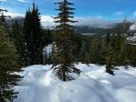
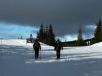
Four hikers brought in 2025 on Jan 1st with a hike to South and North Chinese Mountain. While weather forecasts did not call for any precipitation, we ran into light rain shortly into the trip. The past wind and rain storms were noticeable as the trail was covered with small branches, and special care was required on the rocky bluffs. Yet, the forest was lush and the moss a vibrant green, thick and healthy. We were pleasantly surprised to find a clearing in the clouds and blue sky peaking through on the first lookout on South Chinese.
The group carried on through to the next major lookout on South Chinese and one member lead the group to a hidden part within the rocks to tuck out of the wind where we stopped for lunch and a New Year toast. The winds had picked up and we were reminded that it was winter.
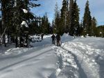
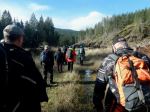
From there, we carried on along the trail to the creek crossing when the bridge is still damaged, but an alternative trail has been started that allowed safe crossing so we could continue.
Once connected to North Chinese Mountain trail, we headed up the both the old and new lookout points. Again, we were blessed with great views despite the winter storm clouds. The light drizzle turned into snowflakes and we were able to take a few pictures of the snow before it melted. A premonition of what Mother Nature has planned for us.
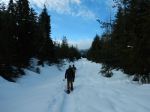
The group turned back and descended on North Chinese Moutain trail back to the parking lot. Overall a fantastic hike with great views peaking through the overcast skies, a light drizzle at times and a few snowflakes.
Total time 2hrs 46min, 243m altitude change and 7.1 km.
Louise
(click on photos to view larger)
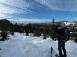
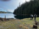
- View SE from South Chinese Mtn
- The broken bridge
- View north from North Chinese Mtn
Snow – Mt. Washington – 8 Jan 2025
| Activity | Snowshoeing |
| Destination | Mt. Washington |
| Date | 8 Jan, Wednesday |
| Trip Coordinator | Norris Weimer |
| Contact Info | norris.weimer@ualberta.ca or 3710. Please contact the coordinator by Monday night. |
| Description | We will follow some of the Mt. Washington snowshoe trails leaving from Raven Lodge. |
| Meeting Place | Quathiaski Cove Ferry terminal |
| Departure Time | 9:00 ferry. |
| Difficulty |
Easy to moderate. |
| Costs | Transportation costs and trail pass. The price of a snow shoe day pass is $16. |
| Trip limits | 10 |
| Dogs? | No |
| Notes: | Bring lunch as we may not eat at Raven lodge. Have reliable equipment and winter gear. Expect warm conditions |
Hiking – Chinese Mtn South and North loop – 1 Jan 2025
Re-scheduled.
| Activity | Hiking |
| Destination | South and North Chinese Mtn Loop |
| Date | 1 Jan 2025, Wednesday |
| Trip Coordinator | Louise Squire |
| Contact Info | lsquire@sasktel.net |
| Description | We will go up the south side to South Chinese Mtn. and have lunch while enjoying the view. Then down the north path and up North Chinese Mtn. and back to the vehicles. |
| Meeting Place | Chinese Mtn parking lot |
| Departure Time | 10:00 |
| Difficulty | Moderate |
| Costs | None |
| Trip Limits | 8 |
| Dogs | No |
| Notes |
Hiking – Maud Island – 6 Jan 2025
| Activity | Hiking |
| Destination | Maud Island |
| Date | 6 Jan 2025, Monday |
| Trip Coordinator | Les Hand |
| Contact Info | 285-2029 or lhquadra@gmail.com |
| Description | We will meet at the Community Center and carpool out to the trailhead. Depending on the weather, we may just stay on the lower trail and not go over Lolo. |
| Meeting Place | Community Centre parking lot |
| Departure Time | 10:30 |
| Difficulty | Moderate |
| Costs | None |
| Trip limits | 8 |
| Dogs? | OK, but must be under control. And on a leash in difficult areas if we go over Lolo, there is a hard spot that is steep for dogs. |
| Notes | Dress for the weather and bring a lunch. This is about a four hour hike, depending on the course that will not be decided until day of the hike. |
Trip Report – Snowden Demonstration Forest – 4 Dec 2024
(click on photos to enlarge)
- Lost Lake
- Lost Lake at the picnic site
- Riley Lake
- Sleepy garter snake
Hiking – Snowden Demonstration Forest – 4 Dec 2024
Trip Report – Carrington Bay & Forest – 27 Nov 2024
Nine of us caught 9:05 am ferry from Heriot Bay to Whaletown on Cortes Island. The day was overcast with glimpses of sunshine. We had a short ride up Carrington Rd to the trailhead where there is ample parking. We hiked a counter clockwise loop through Grandmothers’ Grove to the Lagoon, then on to the campsite at the head of Carrington Bay where we stopped for lunch. Grandmothers’ Grove is through mature Cedar and Douglas Fir with lots of moss and lichen covering the ground and low hanging branches making a very soothing hike. The lagoon was very serene with mist hanging over the water which was like a mirror. The campsite is interesting with some old logging equipment, picnic tables and a makeshift shelter. The lagoon is tidal and the water exits through a narrow channel with an aluminum bridge over it. The main trail coming in and out is old logging road and because of the recent rains there are lots of big puddles. This is not a problem because there is enough foot traffic that there are trails around the puddles. We arrived back at Whaletown with plenty of time to catch the 2:00 pm ferry to Quadra. (8.0 km; 3 hours)
Allan
(click on photos to view larger)
- Views of mainland mountains
- Views of Vancouver Island mtns
- Sun dog
- Carrington Lagoon
- Carrington Lagoon
- Carrington Bay
Trip Report – Beaver Lake and Open Bay Creek – 14 Nov 2024
Ten hikers started out on the Crikey Creek Trail on a chilly but sunny morning. It was nice to get a day without rain for a change. We came out at the Open Bay Main logging road and proceeded down Open Bay Creek. We followed the trail along the creek and were delighted to see chum salmon still spawning in the creek. It has been a record year for returning salmon. Farther down the trail we ran into three large trees that had blown down and were a bit of a challenge to scramble over. We continued on through the mossy forest and turned up the hill to follow the creek to Beaver Lake. Because of the heavy rainfall the Creek was high with many small waterfalls. We had lunch on the rock bluff at the end of Beaver Lake. The creek was a bit of a challenge to get across, but the group managed and continued up the trail beside the lake. As we continued to climb up to Village Bay Lake Road we were treated to rock bluffs with very heavy deep green moss and many different varieties of mushrooms to look at. From there we proceeded back to the vehicles via the Nugedzi parking lot and logging road. (7.4 km and 3 1/2 hours)
(click on photos to enlarge)
- Chum spawning
- Open Bay Creek
- Creek from Beaver Lake
- Bluff over Beaver Lake
- Improvised creek crossing
- The usual crossing


