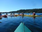
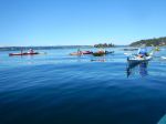
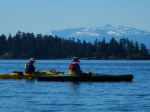
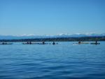
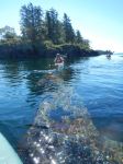
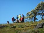
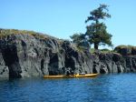
| Activity | Kayaking |
| Destination | Open Bay |
| Date | 6 June 2016, Monday |
| Trip Coordinator | Valerie |
| Contact Info | 250-285-2329 or vvv@qisland.ca. Please contact the coordinator prior to the trip. |
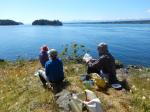
| Description | This will be an intermediate paddle. Depending on currents, weather, we could paddle to/around the Bretons, Moulds Bay, Village Bay, into Hoskyn Channel. Lunch stop to be determined enroute. |
| Meeting Place | Launch site, Breton Rd, Open Bay |
| Departure Time | 10:00 (arrive around 9:30 to prepare) |
| Difficulty |
intermediate, strong winds and currents possible |
| Costs | none |
| Trip limits | none |
| Dogs? | no |
| Notes: | Participants must be prepared for wind and strong currents; kayaks must be ocean kayaks equipped for ocean conditions. If access road is wet we will have to carry/trundle kayaks down a short hill to the beach. Meet at launch site (end of Breton Road) after 9:30 to be on water by 10 am. |
Category Archives: Quadra Island
Hiking – Surge Narrows – 1 June 2016
| Activity | Hiking |
| Destination | Surge Narrows |
| Date | 1 June 2016, Wednesday |
| Trip Coordinator | Julie Mellanby |
| Contact Info | 285-3978. Please contact the trip coordinator prior to the trip. |
| Description | We will hike the trail to the Surge Narrows viewpoint. There will be nearly a 9 knot flood current at 11:00. We will continue on the unmaintained route for additional views of the rapids. |
| Meeting Place | Heriot Bay store parking lot, to arrange carpools |
| Departure Time | 09:00 |
| Difficulty |
easy |
| Costs | none |
| Trip limits | none |
| Dogs? | yes |
| Notes: |
Hiking – Stramberg Old Growth – 25 May 2016
| Activity | Hiking |
| Destination | Stramberg Old Growth |
| Date | 25 May 2016, Wednesday |
| Trip Coordinator | Janis McLean |
| Contact Info | 285-3614. Please contact the trip coordinator prior to the trip. |
| Description | This trail begins near Village Bay Lake and follows open meadows leading into and through the forest on old, unmaintained logging roads. The reward at the end of the hike is a grove of old growth firs. This is not an official trail. Expect blow-down and brush. About 13 km; 5 hours or more. |
| Meeting Place | Heriot Bay store parking lot, to arrange carpools |
| Departure Time | 09:00 |
| Difficulty |
moderate, due to unmaintained trail and quite long |
| Costs | none |
| Trip limits | 10 |
| Dogs? | yes |
| Notes: | Bring lunch and water. |
Trip Report – Gowlland Harbour – 2 May 2016
Thirteen members left Gowlland Harbour Resort on a bright, sunny, calm day for a tour around North and South Gowlland Harbour. Many thanks to resort manager Carmen for allowing us to launch there. We paddled north first toward the log dump and sorting area. There was a lone buck on one of the islands and two otters playing on a dock for entertainment. Some members had not realized how much activity goes on in the log sort. We then paddled to the old shipwreck off May Island and had lunch on the island. The snow-capped peaks of Strathcona Park were stunning against the blue sky.
Next we went to Vigilant Island and watched many seals playing. From here we traveled down the east side of Gowlland Island to the narrow opening into April Point Bay. A few of us tried our skills in the current and found it can be hard in cross current. A word of caution to anyone that does not know this area, the current is not always running the same way as it is outside in Discovery Passage and can be quite fast.
We then paddled around the south end of Gowlland Harbour and up by Stag and Fawn Island. The Sea Blush bloom was early this year, but some flowers were still to be seen. We arrived back at launch site about four hours and 6.5 nautical miles after having left. All and all, it was a stunning day.
Les
Note: Special thanks from all of the participants to Les for the delicious prawns, smoked salmon, cheese and wine contribution to our picnic lunch.
Here is the bird list for the day:
Horned Grebe
Glaucous-winged Gull
Bonaparte’s Gull
California Gull
Double-crested Cormorant
Pelagic Cormorant
Great Blue Heron
Canada Goose
Mallard Duck
Bufflehead
Common Merganser
Pigeon Guillemot
Marbled Murrelet
Bald Eagle
Belted Kingfisher
Northwest Crow
Common Raven
Pacific Wren
American Robin
Spotted Towee
Townsend’s Warbler
- Buck
- The wreck underwater
- Lunch on May Island
- Sea blush
- Vigilant Island
- Bay at the north of Gowlland Island
(click on photos to view larger)
Hiking – Mt. Seymour logging roads- 13 May 2016
| Activity | Hiking |
| Destination | Mt. Seymour logging roads |
| Date | 13 May 2016, Friday |
| Trip Coordinator | Norris Weimer |
| Contact Info | norris.weimer@ualberta.ca or 3710. Please contact the trip coordinator prior to the trip. |
| Description | We will hike around Mt. Seymour on old logging roads and flagged routes. There are several lovely small lakes along the way. The route goes up around the backside (west) of the mountain but does not go to the summit. There are some good viewpoints on the north side. A car shuffle will be done. |
| Meeting Place | Heriot Bay store parking lot, to arrange carpools |
| Departure Time | 09:00 |
| Difficulty |
moderate but long |
| Costs | none |
| Trip limits | none |
| Dogs? | |
| Notes: | 14.3 km. The logging road going up is very rough walking. Once we are high, the logging roads are mostly flat and easy, but not maintained. There may be wet places and bugs. |
Kayaking – Gowlland Harbour – 2 May 2016
| Activity | Kayaking |
| Destination | Gowlland Harbour and small islands within |
| Date | 2 May 2016, Monday |
| Trip Coordinator | Les Hand |
| Contact Info | 250-202-4455 or leshand@gicable.com. Please contact the coordinator by April 29 |
| Description | We will circumnavigate Gowland Harbour exploring some of the small islands as we go. We will stop on May Island for lunch. There should be a beautiful display of flowers this time of year. |
| Meeting Place | Gowlland Harbour Resort parking lot, 823 Gowlland Harbour Rd. |
| Departure Time | 10:00 A.M. (unload and prepare at 9:30) |
| Difficulty |
easy to moderate |
| Costs | none |
| Trip limits | limited by parking to 10 vehicles |
| Dogs? | no |
| Notes: | Bring your kayak and all necessary safety equipment. If you have not completed your 2016-17 membership, please come prepared to sign papers and pay the membership fee. Only 2 vehicles can unload at beach at one time so please be on time. We will paddle South Gowlland and North Gowlland, about 4 hours weather permitting. Bring a lunch. If pouring rain or high wind, e-mail will be sent out by 8 am postponing trip. Gowlland Harbour Resort has kindly granted us permission to use their boat launch for this trip. This is not a public access. |
Trip Report – Mt. Seymour – 13 Apr 2016
Ten people and two dogs climbed Mt. Seymour. We all stayed dry while watching rain clouds over Vancouver Island. We visited the east, north and west viewpoints and enjoyed a short lunch stop trying to huddle out of the wind (6° C). We hiked quickly and enjoyed the workout. 3½ hours, 8 km, 425m elevation gain.
Julie
- Discovery Passage
- At the summit
- Georgia Strait
(click on photos to view larger)
Trip Report – Cape Mudge Loop – 6 Apr 2016
When Wednesday dawned grey and drizzly we decided to postpone the trip to Mt. Washington and go for a walk instead. We set out on a loop on the Cape Mudge Reserve of logging roads, streets and trails. We started on an old road off of the road to the Lighthouse, hopped across the wetlands and continued into the village. We followed the trail along the shore, which has been much eroded from the recent storm surge, continued past the campground, Lighthouse, Tsa Kwa Luten and into the forest trail which returned to the road. There were lots of flowers to admire along the way. 9km; 2½ hours.
- Carvings in Cape Mudge Village
- Carvings at the Museum
- Pink Fawn Lily
- Salmonberry
- Current flowers
- Dead sea urchin
(click on photos to view larger)
Trip Report – Beech’s Mtn Loop – 30 Mar 2016
Eight hikers and one dog enjoyed a spectacular sunny day on this five hour hike, including guests Dina and Daryl from the Bulkley Valley. The maintained trail, which branches off South Chinese Mountain trail, was followed to the top of Beech’s Mountain, the second highest point on Quadra Island after Mt. Seymour. Our lunch break was spent overlooking an 180 degree panorama of the east side of Quadra and beyond to the mainland.
From the top of the mountain, we followed a flagged route down and around the mountain, and onto the North Chinese ridge at its north end. From there, the route over sunny mossy bluffs took us back to the North Chinese Mountain trail near the point where it heads up to North Chinese Mountain viewpoint. We headed down the steep rubbly trail/old logging road and back to the vehicles at the Chinese Mountain parking lot. There were lots of stops to appreciate the views across to both the Vancouver Island and Coast Mountains, as well as views south down Georgia Strait.
I think this is one of the best hikes for stunning views on a clear day. Hiking level is moderate with sustained uphill and a few short difficult sections over bluffs on the way up the mountain. The route on the second half of the hike includes two long downhill sections of rock-strewn old logging roads which can be hard on tender knees. Walking sticks are recommended.
Janis
(click on photos to view larger)
Trip Report – Silk Stocking and Little Black Dress – 16 Mar 2016
Four hikers and one dog set off on the first sunny day we have had after weeks of heavy rain and gloomy skies. The trail was less sloppy than we had feared, which was welcome surprise. The sun filtered through the trees and the moss was a glowing neon green – almost too bright to look at! We made a loop down “Dick’s Ride” to check out the beaver pond with a collection of Mallard and Greater Scaup bobbing about on the calm water. Then we climbed back up the hill to get out on the mossy bluffs and into the glorious sunshine. Our lunch spot was a rocky outcrop with a view back toward Gowlland Harbour. As we ate, a group of wolves started to howl on the ridge to the south-west of us, and they continued their chorus for about twenty minutes as we started our descent – lovely!!
This section of Silk Stocking skirts the old copper mining area, now inactive for 60 to 70 years. There are bits of machinery still around and in some spots the rock has the classic bright green colour of copper ore. It is impressive how much the land has recovered from the scarring of mining activity – moss and young growth now covers the seams where ore had been taken out. It is a gorgeous section of the trail and hopefully will not be devastated by mining activity again.
Our last treat was a view of two Hooded Mergansers on the body of water at the base of the ridge. Then a twisty section of trail along Little Black Dress returned us to our starting point with almost dry feet.
Bird list for the day:
Harlequin Duck
Greater Scaup
Mallard
Hooded Merganser
Sooty Grouse
Bald Eagle
Pileated Woodpecker
Common Raven
Northwestern Crow
Golden-crowned Kinglet
Chestnut-sided Chickadee
Pacific Wren
American Robin
Spotted Towhee
Dark-eye Junco
Song Sparrow
Kathryn
- Beaver Pond (Wood Duck Lake)
- Copper ore
- Mark and Luna listening to wolves
- Merganser pond
- Mine area – Gowlland Hbr beyond
- Mining equipment
- Old mine seams
- Walking in sunshine
(click on photos to view larger)


