Trip Report – Ripple Rock Trail – 13 May 2025

Three of us and two dogs hiked out from trailhead at Highway 19 to the viewpoint overlooking former Ripple Rock. Blasted in 1958, it was the largest non nuclear blast up until that time. It was a beautiful sunny day with slight breeze so temperature was ideal for hiking. With no significant rainfall for awhile the trail was dry with no mud or slippery sections. We walked the trail at a good pace with dogs helping us along. The whole route out and back was 9 km and took 3 hours and 6 minutes, with a 15 to 20 minute break for a snack at Ripple Rock viewpoint. The last uphill stretch to parking lot was a bit exhausting, but welcome once there.

Allan
 
Thanks to Allan for the photos
 

(click on photos to enlarge)

Hiking – Ripple Rock Trail – 13 May 2025

Trip Report – Trout Creek Falls – 7 May 2025

On a sunny spring day, nine hikers drove out Menzie’s Main to the start of the trail. There is a easy place to park just before and after the bridge over Mohun Creek, which used to be called Trout Creek. It is only a short walk to the first of three waterfalls. The first is impressive, but smaller. The trail has lots of rocks and roots in it so you must be careful not to trip. The trail has been used extensively already this spring. As you hike up the trail, there are many pools and rapid areas that are very picturesque. The second waterfall is the highest and very beautiful. The trail is very steep here so you need to be careful not to slip. The third waterfall is short but very impressive as it drops over a rock face and then makes a sharp right down a rocky ravine before it drops more. We carried on and had lunch on the rock bluff above the waterfall. After lunch we hiked out to the old logging road, stopped briefly at Mary Lake and then returned to the vehicles.
7 km in about three hours

Les
 
(click on photos to enlarge)
 

Hiking – Trout Creek Falls Loop – 7 May 2025

Hiking – Ripple Rock – 13 May 2025

Activity Hiking
Destinatio Ripple Rock Trail, Campbell River
Date 13 May, Tuesday
Trip Coordinator Allan Liimatta
Contact Info allanliimatta@gmail.com; 1 250 416 9338
Description Ripple Rock Trail starts 16 km north of Campbell River. It is a moderate hike through a lovely forest. The trail undulates over 9 km (RT), taking 4 to 4.5 hours return. There are several metal bridges, and a 47-step staircase near the top.
Meeting Place QCove ferry line up
Departure Time 10:00 ferry
Difficulty
Moderate
Costs Ferry and gas
Trip limits 10
Dogs? Bring a leash.
Notes: Please arrange your own carpools. Bring a lunch and dress for the weather.

Paddling – Amor Lake – 21 May 2025

Activity Paddling
Destination Amor Lake
Date 21 May, Wednesday
Trip Coordinator Darcy Mitchell
Contact Info mitchelldarcy51@gmail.com
Description Amor Lake is an interesting and attractive lake with several sandy beaches and a hiking option (about one hour round trip for the hike). Driving distance to the launch site is about 45 minutes from the ferry.
Meeting Place Drive-in campsite on the west side of Amor Lake
Departure Time On the water at 11:00
Difficulty Easy
Cost Ferry
Trip limits 8
Dogs? No
Notes: Trip timing is flexible, but we will likely be out for about 5 hours. Please contact the coordinator no later than Sunday, May 18. If the weather will be cancelled for any reason, I will send a note to registrants by noon on Tuesday.
For more information about the Rec site visit: https://www.sitesandtrailsbc.ca/search/search-result.aspx?site=REC0174&type=Site

Trip Report – Canyon View and Elk Falls – 23 Apr 2025

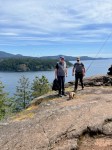
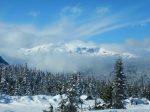
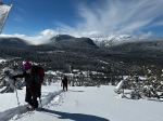
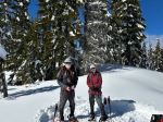
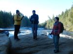
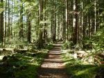
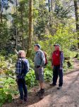
Five Club members and one of the four-legged persuasion took full advantage of a beautiful, uncrowded spring day to enjoy the many signs of spring bursting all around us on this hike. While the actual hike, Canyon View Trail to Millenium Trail to Elk Falls Provincial Park, and return, is guaranteed to give a good workout, the bonus was the opportunity to enjoy so much else this local treasure has to offer.

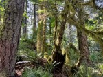
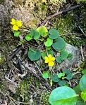
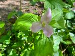
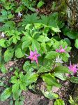
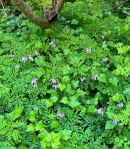
We were quickly delighted to find that the pink fawn lilies were still in bloom, and, in fact abundant, along both sides of the Canyon View Trail, as well as wild bleeding hearts, trilliums, and yellow violets, and few other unnamed wild flowers. The salmonberries are just beginning to flower, along with the elderberry bushes.

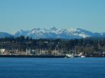
Our knowledgeable birder’s identifications began at QCove then along the Campbell River, sightings included Yellowlegs, Eagle, Killdeer, Pine Siskins, and Mergansers.

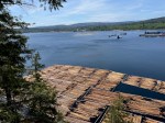
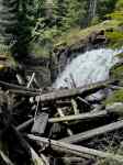
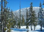
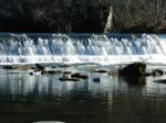
Apart from Nature’s offerings, this trail is also a fascinating engineering study. Watching the progress since initiation, in 2014, of the new generating plant, the seismic upgrades and restoration work on the John Hart Dam has been most interesting. The former penstock valley is now being regraded and restored, completion projected for 2030. As this trail was new to two of our members, we all enjoyed the opportunity to read the excellent signage explaining this massive project.

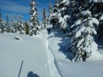
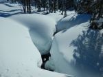
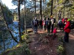
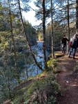
The north side of the Canyon View Trail has just been reopened following improvements made to the upper end. We followed a diversion through alder scrub out to the beaver ponds and spawning channels to the north of the river, these quiet channels would be great swimming holes in the summer. Rejoining the main trail, we were impressed with the new boardwalks in the hilly, muddy areas, providing much more secure footing and preventing further erosion.

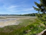
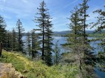
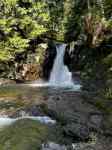
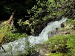
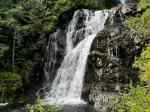
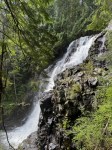
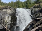
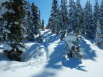
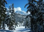
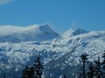
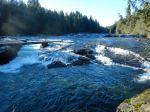
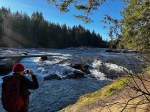
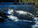
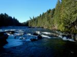
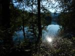
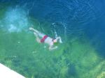
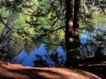
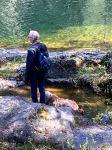
Once in Elk Falls Park, we enjoyed lunch warmed by the sunshine pouring into the picnic area, then followed the outer loop to the river. All along this hike we marvelled at the old growth trees, mostly spruce, some fir and cedar. We stopped at the Dolphin Pool to gawk at the changes, yet again, to the Dam and seismic infrastructure visible across the pool. Further on, one of our hikers took full advantage of a small riverside pool to cool off.

A trip over the suspension bridge is mandatory on this hike, its construction was another source of examination and discussion. This suspension bridge is certainly more secure than the wood slats (always some missing) and wire ropes of the old Lyn Valley bridge (North Vancouver) of my youth, but not as thrilling.

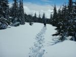
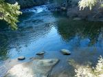
We returned on the south side of the river, again reconstruction and restoration of the trail up to the Highway bridge was noted. After crossing the bridge, the trail is still a rough, woodlands trail following the river. Altogether a beautiful hike offering many added delights. (12.5 km; 4 ¾ hours)

Valerie van Veen

Thanks to Valerie for the photos

(click on photos to view larger)

Hiking – Canyon View and Elk Falls – 23 Apr 2025

Hiking – Trout Creek Falls – 7 May 2025

Activity Hiking
Destination Trout Creek Falls
Date 7 May, Wednesday
Trip Coordinator Les Hand
Contact Info lhquadra@gmail.com or 285-2029
Description We will leave on the 10:00 ferry so be sure to be there early enough. We will then drive the short distance out Menzie’s Main to the trailhead. This is a basic trail, with a few steep sections and three waterfalls. We will do a circle route coming back on a logging road. This is about 5 km and 2½ hours so it will not be a long hike.
Meeting Place QCove ferry terminal
Departure Time 10:00
Difficulty
Moderate
Costs Ferry
Trip limits 10
Dogs? No
Notes: Be sure to contact the coordinator by Monday night as we need to arrange carpooling; also, so I may contact you if the hike is postponed. Dress for the weather and bring a lunch.

Hiking – Canyon View and Elk Falls – 23 April 2025

Activity Hiking
Destination Canyon View Trail and Elk Falls, Campbell River
Date 23 April, Wednesday
Trip Coordinator Valerie van Veen
Contact Info 250 285 2329 vvv@qisland.ca (cell) 778 242 5774
Description Hopefully we will still see some spring flowers along this lovely, newly refurbished trail that follows the Campbell River. Weather permitting, we will then head uphill to the Elk Falls Park. Lunch at Elk Falls, return on River Trail. We will start from the parking lot on the north side of the river across the “log” bridge.
Meeting Place Q Cove Ferry terminal.
Departure Time 10:00 ferry
Difficulty
Moderate
Costs Ferry
Trip limits None
Dogs? On leash; warning.. the ramps and bridge at Elk Falls are made of metal grids that are hard on dogs’ feet
Notes: Bring lunch. We will hike at a leisurely pace to really enjoy this beautiful area. Unless extreme weather, we will at least do the Canyon View Trail. About 2 – 4 hours, 5 – 10 km depending on route. Carpool from ferry if wanted.

Trip Report – Mt. Washington – 12 Mar 2025

Since the planned paddle was cancelled due to a wind forecast, we switched to a snowshoe trip.  And the weather at Mt. Washington was a surprise – sunshine and 18 cm fresh snow.  Three of us went up Great Big View following a broken track, then we went on Finger Glades.  The snow and the views were great.  We stopped for lunch and shortly after the broken track ended.  We decided to continue anyway and the route carried on and up.  Eventually we joined a track left by skiers for a while.  Then we were breaking trail again.  We followed the wands for Marmot’s Mess in the wrong direction until we cut cross-county back to the Great Big View trail. Jim was the champion trail breaker and super fixer of a broken crampon.
(5.7 km, 4 hours, 275m ascent)

Norris

Thanks to Jim and Norris for the photos

(click on photos to view larger)

Snow – Mt. Washington – 12 March 2025

Previously scheduled on March 3rd.

Activity Snowshoeing
Destination Mt. Washington
Date 12 March, Wednesday
Trip Coordinator Norris Weimer
Contact Info norris.weimer@ualberta.ca or 3710.  Please contact the coordinator by Saturday evening
Description We will head uphill from the Nordic centre taking the trails for Big View and Finger Glades.  Some sections are quite steep. About 5.5 km, 250 m elevation gain, 3.5-4 hours.  Snowshoes can be rented if needed and there is a $16 day pass that is required.
Meeting Place Quathiaski Cove Ferry terminal
Departure Time 9:30 ferry
Difficulty
Moderate
Costs Ferry, fuel and $16 Day Pass
Trip limits 10
Dogs? No
Notes: There is a lot of recent snow on the mountain now.. Bring lunch and gear appropriate for the weather.

Trip Report – Nymph Falls to Comox Lake – 27 Jan 2025

This was a very popular hike because we had never done it before and the weather was beautiful and crisp.  Thirteen of us took the ferry and then drove to the Comox Valley, parking at the Nymph Falls Nature Park.  We briefly walked down stream along the Puntledge River to view the falls, with its rock ledges and wide span.  We then followed the well constructed and maintained trail upstream to the weir, past the islands, through the mature forest and meandering trail, arriving at the dam.

Conveniently, there were picnic tables mostly in the sun for our lunch.  We wandered out to the bridge on the Comox Main logging road for a narrow view of Comox Lake and watched a guy jump into the frigid January water.  We then turned back and mostly returned by the same route, with a few short-cuts.  The group enjoyed the great weather, easy walking, the new scenery and the sociability. 14.2 km; 4½ hours.

Debbie 

Thanks to Jim and Norris for the photos

(click on photos to view larger)

Hiking – Nymph Falls to Comox Lake – 27 Jan 2025