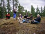
| Activity | Hiking |
| Destination | Heriot Ridge Route |
| Date | 29 June 2014, Sunday |
| Trip Coordinator | Debbie Quigg |
| Contact Info | 285-3710; Please contact the coordinator prior to the trip |
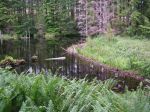
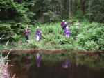
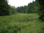
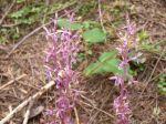
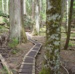
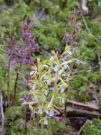
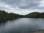
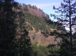
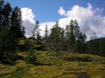
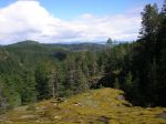
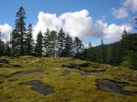
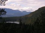
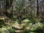
| Description | This hike is a loop following the Heriot Ridge. It first follows the Heriot Ridge trail up to the ridge where there are excellent views to the east and west. The hike then continues on the ridge on a well-used flagged route, not a maintained trail, for about a third of the distance. The route undulates through open forest and bluffs until it joins the Thompson Trail and descends to Thompson Rd. About 2 hours. |
| Meeting Place | Heriot Bay Store for possible car pooling |
| Departure Time | 1:00 |
| Difficulty | easy |
| Costs | none |
| Trip limits | none |
| Dogs? | |
| Notes: |
Category Archives: Quadra Island
Trip Report – Wood Duck Lake – 19 June 2014
Despite the forecast for rain and gale force winds later in the day, the group of eight proceeded with this hike to an area not familiar to most of the participants. Taking the second logging road on the right after turning onto North Gowlland road, we parked about a half a kilometre down the road, just past a recently harvested area. The mountain bike trail known as Yellow Mud branched to the left and led to a series of meadows and to Wood Duck Lake. The beaver dam, which had failed a few years ago causing some down-stream damage, was in good repair. There were Mergansers with babies on the lake. We continued on and then up on Play Thing trail to an old copper mining site. Finding the Back Door trail we followed this through open forest until we reached a bluff with views of the Chinese Mountain – Beech’s Mountain ridge. We returned via Dick’s Ride trail, making a small loop. 7 kilometres. The rain and wind held off until we got home.
- beaver dam
- Wood Duck lake
- beaver dam
- Rolf
- track in Google Earth
(click on photos to view larger)
Trip Report – Nugedzi – 14 June 2014
The group explored all of the Nugedzi highpoints: the old cedar grove, the lakes, the viewpoint over Discovery Passage, the lily pond and the viewpoint over Georgia Basin. The weather was overcast and hazy, even murky, and there were a few drops of rain at lunch, but the temperature was fine for the climb up the logging road. The wildflowers were excellent, though the forest is unusually dry for this time of year. (If the flowers are not all identified correctly, let us know). The pace was leisurely, with stops at all the beauty points for food and talk. 11.4 kilometres.
(click on photos to view larger)
- Coral Root
- the old forest
- Saprophytic Orchids
- Nugedzi Lake
- Bunchberry/Dwarf Dogwood
- Sandwort
- Davidson’s Penstemon
- Death Camas
- Bonsai hemlock
- Labrador Tea in bloom
- Rebecca Spit
Hike Nugedzi 14 June 2014
| Activity | Hiking |
| Destination | Nugedzi Lakes |
| Date | Saturday, 14 June 2014 |
| Trip Coordinator | Norris Weimer |
| Contact Info | 285 3710; please contact the coordinator in advance of the trip. |
| Description | Hike up an old logging road and meander through open forest to the lovely Nugedzi Lakes. If the group wants more, there are side trips to viewpoints looking southeast and west. |
| Meeting Place | Heriot Bay Store for car pooling |
| Departure Time | 10:00 A.M. |
| Difficulty | moderate |
| Costs | none |
| Trip limits | none |
| Dogs? | |
| Notes: | Bring lunch |
Trip Report – Paddling practice strokes, bracing, rescues 28 May 2014
We had a sunny, breezy day for our paddling practice at Mine Lake. Jill, with help from Charlie, led a great session. After a short talk on the beach, the eight of us kayaked over to a more sheltered bay in the southwest corner of the lake. On the way over we practiced strokes and bracing. Everyone did at least one successful dump and re-entry, but each person chose what they wanted to do and how much. The water temperature was fine. We paddled through the narrows to Village Bay, practicing rafting up and getting an unconscious person back into a kayak along the way. Then we paddled back to the boat launch with the rising northwest wind at our back. We had drinks and snack on Les’ tailgate before packing up and leaving. Thanks very much to Jill and Charlie for their tremendous help on this.
Some take-away ideas: Practice bracing so you don’t end up dumping. Stay with the group, it’s easier to rescue if you have help. Don’t let go of your paddle or your boat.
- strokes
- Jill
(click on photos to view larger)
Trip Report – Morte Lake Loop – 21 May 2014
We had a great group of eight hikers, but not great weather for this hike around Morte Lake. The day started with overcast and worked up to drizzle and rain.
We used some route variations to make this loop around Morte Lake, rather than the official maintained trail. We started on George’s flagged route which leaves directly from the parking lot and climbs steeply up to the ridge south of the creek flowing from Little Morte Lake. Everyone helped to find the next flag and we stayed on course. The mossy bluffs and death camas were lovely, but the views were quite limited by the weather. From the ridge summit we joined the under-construction mountain bike trails that lead along the ridge, down to a saddle and up again to the Dead Fish mountain bike trail. We continued on mountain bike trails down to the official maintained trail and then followed the trail clockwise around Morte Lake. We stopped for lunch at the southwest lake viewpoint and admired the sandy beaches along the way. After Little Lake we crossed the creek and re-joined the mountain bike trail, through an open forest with good views of the creek. There were newts and oyster mushroom along the way. About 11.5 km, a bit more than 4 hours.
- South Chinese Mtn.
- Morte Lake
- Oregon Grape
- Oyster mushrooms
(click on photos to view larger)
Some of the posted photos were taken on a sunnier day earlier in May.
Paddling practice strokes, bracing, rescues 28 May 2014
| Activity | Kayaking |
| Destination | Mine Lake |
| Date | 28 May 2014, Wednesday |
| Trip Coordinator | Jill Sampson |
| Contact Info | 285- 3202 |
| Description | Practice kayak strokes, bracing and rescue techniques |
| Meeting Place | Mine Lake boat launch. |
| Departure Time | 1:00 |
| Difficulty | The difficulty will depend on what you want to do |
| Costs | none |
| Trip limits | none |
| Dogs? | no |
| Notes: | You don’t have to dump in the water if you don’t want; you can come and practice strokes and bracing. Bring dry clothes, towels and snacks. We hope to have a fire on the beach. |
Trip Report – Main Lake 12-14 May 2014
Five club members enjoyed the first multi-day paddle of the season, camping at Main Lake and touring all the corners of the park. We set off from the Mine Lake boat launch on an overcast Monday morning which turned to drizzle later in the day. As the campsite is well equipped with a picnic table and a frame above it for setting up tarps, we were comfortable and dry. In the afternoon, we paddled down to the south end of Village Bay Lake to the fish counting gate, and returned for an excellent supper featuring prawns in garlic butter, supplied by Les. After a drizzly night, Tuesday dawned sunny and calm. With high water levels, we were able to paddle up the channel to Little Main Lake – a highlight of the trip. One of the group headed home in the afternoon due to a bad cold, while the rest enjoyed the campfire, the moonrise and a nocturnal visit from a rather large frog. On Wednesday morning we paddled to the east end of Main Lake, walked the old portage trail to Yeatman Bay and enjoyed the view from the tidal island at the mouth of the bay. We arrived back at the launch site about two o’clock.
- mouth of Clear Creek
- Shadow Brook to Little Main
- Little Main Lake
- Shadow Brook
- Main Lake
- Main Lake
- frog
- Main Lake
- the walk to Yeatman Bay
- view from Yeatman Bay
- sea blush
- Yeatman Bay
(click on photos to view larger)
Basic kayak navigation 28 May 2014
POSTPONED
| Activity | Basic kayak navigation: tides and currents |
| Location | TBA |
| Date | |
| Instructor | Valerie van Veen |
| Contact Info | vvv@qisland.ca; 250 285 2329 |
| Description | This course will provide basic information on tides and currents for kayakers. It is the second course in a series, following the course on charts and compass |
| Meeting Place | TBA |
| Time | 3:00 pm for two hours |
| Difficulty |
basic, appropriate for all who want to understand tides and currents for kayakers |
| Costs | none |
| Trip limits | none |
| Dogs? | no |
| Notes: | Interested participants are encouraged to phone/email Valerie with any specific questions and what they are particularly interested in learning during this session. |
Paddling/camping Octopus Islands 2-4 June 2014
| Activity | Multi-day Paddle |
| Destination | Octopus Islands |
| Date | June 2 – 4; Monday to Wednesday |
| Trip Coordinator | Darcy Mitchell |
| Contact Info | darcm@telus.net or 285 2739 |
| Description | A three-day, two night paddle and camping trip to the Octopus Islands via Beazley Passage/Surge Narrows. This is a very scenic area that offers opportunities for both paddling and hiking (to Newton Lake and/or from Waiatt Bay to Small Inlet). |
| Meeting Place | Discovery Islands Lodge, almost at the end of Surge Narrows road. Driving time 45-50 minutes from the Cove. |
| Departure Time | One p.m. in order to transit the Narrows just before slack, which is 1:54 p.m. Allow at least one hour to unload cars and pack kayaks, so arrive by noon at the lodge. |
| Difficulty |
Moderate |
| Cost | Launching fee – $10.00 per kayak (special reduced price for the Club!) |
| Trip limits | 8 (no more than 6 tents, preferably 4) |
| Dogs? | no |
| Notes: | Please let the coordinator know at least 4 days before the trip if you will be going – by email, please. The trip is weather dependent and the final ‘call’ will be made by email by 5 p.m. on Sunday, June 1. Trip participants must be capable of self-rescue. You can drive down to the dock at the lodge to unload, but cars must be parked in the upper parking lot. If you are the first to arrive, please walk down the hill from one of the upper parking lots to make sure there is room to bring vehicles down to unload. If you are interested in renting a kayak for this trip, please contact Coast Mountain Expeditions directly. |


