| Activity | Hiking |
| Destination | North Gowlland Harbour bike trail loop |
| Date | 5 July 2017, Wednesday |
| Trip Coordinator | Janis McLean |
| Contact Info | 285-3614; please contact the coordinator in advance of the trip. |
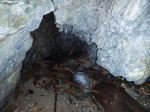
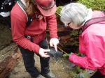
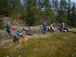
| Description | Carpool to North Gowlland Habour Road trailhead. We will traverse a large loop of mountain bike trails, passing by the old copper mining area on Silk Stocking trail, and returning to the vehicles via trails and old logging roads. 3 hours. Bring lunch or snack. |
| Meeting Place | Heriot Bay store parking lot |
| Departure Time | 9:00 |
| Difficulty |
easy to moderate |
| Costs | none |
| Trip limits | 10 |
| Dogs? | yes |
| Notes: |