Now scheduled for 21 June 2017
| Activity | Hiking |
| Destination | Beech’s Mountain Loop |
| Date | 21 |
| Trip Coordinator | Janis McLean |
| Contact Info | 285-3614; please contact the coordinator in advance of the trip. |
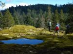
| Description | Carpool to Chinese Mountain parking lot. HIke up South Chinese Mountain trail and carry on to Beech’s Mountain summit. From there, we will drop down the far side of Beech’s and follow a route which will bring us to the North Chinese Mountain trail and back to the vehicles. Time – 3 hours. Bring a lunch or snack. |
| Meeting Place | Heriot Bay store parking lot |
| Departure Time | 9:00 |
| Difficulty |
moderate |
| Costs | none |
| Trip limits | 10 |
| Dogs? | yes |
| Notes: |